... a piece of old Japan finds new life in Buenos Aires
written in 2007 ...
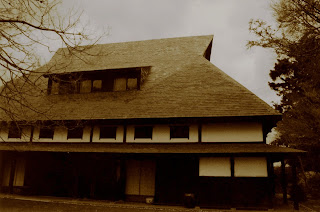
Having lived and worked in Japan for 32 years, Guillermo Bierregaard, who made his fortune in shipping and advertising, and his wife Patricia Palacios Hardy de Bierregaard, a banker and descendent of English novelist Thomas Hardy, returned to their native Argentina, bringing with them their extensive collection of modern Japanese sculpture, baskets, furniture and abstract art. Also shipped over and now rebuilt in all its glory was another unique piece, their 200-plus-year-old Japanese house made from gassho-zukuri wood, which having been reassembled piece by piece is just as much a museum piece as the collection inside, which dates from 1868 to the present. The result of more than 20 years of vision and preparation? The stunning La Casa de Japón, also known as the Minka (Japanese farm house).
As of October 5, the Bierregaard’s personal mission to showcase a timeline of recent Japanese art will open to the public, an inspiring reason to visit the quiet Buenos Aires suburb of San Isidro, away from the pace of the capital’s newly re-energized downtown. “Japanese art has never properly been explained or represented in South America,” says Bierregaard, “and we could think of no better way of displaying it than to also bring the house over.”
The collection is both inside and outside the house, which the Bierregaards purchased in 1979 from members of the 33rd generation of a noble Japanese family living in the mountains of Fukui Prefecture, some 200 miles west of Tokyo. In 1984, they decided to dismantle the house and rebuild it in the prefecture of Gifu, near the city of Nagoya, under the eye of Frank Lloyd Wright disciple Junzo Yoshimura, whose seamless join between airy house and leafy garden exudes a peace perfect for the collection. Yoshimura also designed the Residence at Pocantico Hills, just north of Tarrytown, N.Y., for Nelson Rockefeller in the late 1970s, which, as does the Casa de Japón, displays furniture by George Nakashima. “After the house arrived, we came to Buenos Aires with Japanese carpenters, who rebuilt the structure together with Argentine workers,” explains Bierregaard.
Among other pieces on display are sculpture by Hayami Shiro and Suzuki Osamu, ceramics by Nakamura Kimpe and Koie Ryoji, glass by Masuda Masanori, and bamboo basketry, the intricacy of which is simply stunning, by Shono Shounsai and Iizuka Shokansai. Celebrated Japanese-American artist Isamu Noguchi is represented, and many of those on display remain alive in Japan, where they are considered “living treasures.” Bierregaard has chosen not to collect paintings on canvas, but visitors should definitely check out the house’s huge structural beams, works of art in their own right.
And the Casa de Japón remains very much a living museum, with the Bierregaard’s resident on its third and fourth floors.
Minka/La Casa de Japón, Capitán Juan de San Martín 1596, San Isidro, Buenos Aires; (011) 54/11-4737-9293; minka_en@yahoo.com.ar; entrance, ARG$15 (£3).


